- Cartas e Publicações
-
Indústria Naval

-
Náutica

-
Indústria Terrestre

-
Equipamentos p/ portos

- Proteção Covid-19
- Sobre Nós
- Novidades
- Marcas
- Contactos
- Serviços
- Catálogos
- Home /
- Cartas e Publicações /
- Cartas Náuticas /
- Admiralty
Admiralty

The United Kingdom Hydrographic Office (UKHO) provides hydrographic and geospatial data to mariners and maritime organisations across the world.
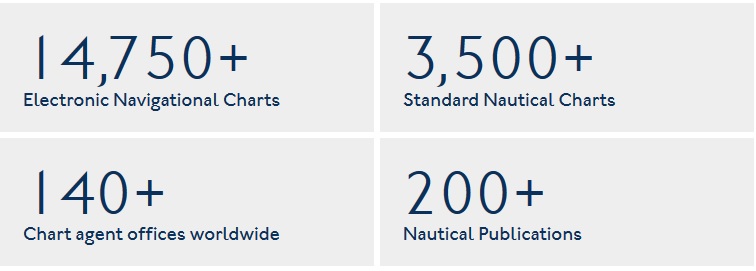
Our market-leading portfolio of ADMIRALTY Maritime Products & Services are found on over 90% of the world's ships trading internationally and provide the widest official coverage of the world's busiest international shipping routes and ports. Depended on by mariners for over 200 years, the range includes over 250 paper and digital publications, 3,500 Standard Nautical Charts (SNCs) and over 14,750 Electronic Navigational Charts (ENCs).
As leaders in our field, our global reputation is based on the reliability of hydrographic and geospatial information. That's why we employ global experts including cartographers, hydrographic surveyors, tidal experts and master mariners to ensure this information is up to date.
These experts help us to collect, compile, analyse and supply global maritime data in a wide variety of formats, including millions of items per year under the ADMIRALTY Maritime Products & Services brand. This data includes tidal height and tidal stream data, navigational hazards, over 70,000 individual light structures, port information, climatic conditions, maritime radio communications information and security-related information.
Admiralty
- Admiralty Planning Charts
-
Admiralty Standard Nautical Charts
- Folio covers for Admiralty charts
- Folio 1 - SOUTH COAST OF ENGLAND
- Folio 2 - BRISTOL CHANNEL AND SOUTH COAST OF IRELAND
- Folio 3 - IRISH SEA, FIRTH OF CLYDE AND NORTH COAST OF IRELAND
- Folio 4 - WEST COAST OF IRELAND
- Folio 5 - WEST COAST OF SCOTLAND
- Folio 6 - NORTH AND EAST COASTS OF SCOTLAND
- Folio 7 - NORTH SEA INCLUDING FIRTH OF FORTH TO THAMES ENTRANCE
- Folio 8 - RIVER THAMES AND MEDWAY AND APPROACHES
- Folio 9 - EASTERN SHORE OF NORTH SEA, CALAIS TO SKAGEN
- Folio 10 - BALTIC SEA
- Folio 11 - GULFS OF FINLAND AND BOTHNIA
- Folio 12 - NORTHERN SHORES OF THE SKAGERRAK
- Folio 13 - WEST COAST OF NORWAY
- Folio 14 - NORWAY, NORTH OF TRONDHEIM AND RUSSIAN ARTIC
- Folio 15 - FAROE ISLANDS, ICELAND AND SVALBARD
- Folio 16 - NORTH COAST OF FRANCE AND CHANNEL ISLANDS
- Folio 17 - WEST COAST OF FRANCE AND NORTH COAST OF SPAIN
- Folio 18 - WEST COAST OF SPAIN, PORTUGAL, STRAIT OF GIBRALTAR
- Folio 19 - EASTERN NORTH ATLANTIC OCEAN
- Folio 20 - NORTH WEST COAST OF AFRICA
- Folio 24 - STRAIT OF GIBRALTAR TO MALTA AND PORT SAID
- Folio 25 - MEDITERRANEAN COASTS OF SPAIN AND FRANCE
- Folio 26 - WEST COAST OF ITALY
- Folio 27 - ADRIATIC AND WEST COAST OF GREECE
- Folio 28 - CRETE AND WESTERN AEGEAN SEA
- Folio 29 - EASTERN AEGEAN AND MARMARA DENIZI
- Folio 30 - ESTERN MEDITERRANEAN - RHODES TO EL ARISH, INCLUDING CYPRUS
- Folio 31 - BLACK SEA ANS SEA OF AZOV
- Folio 32 - RED SEA, GULF OF ADEN AND ARABIAN SEA
- Folio 34 - SOUTH WEST COAST OF AFRICA
- Folio 35 - EASTERN SOUTH ATLANTIC OCEAN, SOUTH AFRICA AND SOUTHERN OCEAN
- Folio 36 - EAST COAST OF AFRICA
- Folio 37 - MADAGASCAR
- Folio 38 - CHAGOS ARCHIPELAGO, MAURITIUS AND REUNION
- Folio 40 - PERSIAN GULF
- Folio 41 - PAKISTAN AND WEST COAST OF INDIA
- Folio 42 - SRI LANKA AND APPROACHES
- Folio 43 - EAST COAST OF INDIA, BANGLADESH, BURMA AND ADAMAN ISLANDS
- Folio 45 - MALLACA STRAIT
- Folio 46 - WEST COAST OF SUMATRA AND SOUTHERN APPROACH TO SINGAPORE
- Folio 47 - WESTERN SIDE OF CHINA SEA
- Folio 48 - EASTERN SIDE OF CHINA SEA AND SULU SEA
- Folio 50 - HONG KONG ISLAND TO YANGTZE KIANG INCLUDING TAI WAN
- Folio 52 - YELLOW SEA, BO HAI
- Folio 53 - WESTERN AND SOUTH COASTS OF JAPAN
- Folio 54 - INLAND SEA OF JAPAN
- Folio 55 - NORTHERN HONSHU AND HOKKAIDO
- Folio 56 - SEA OF OKHOTSK TO NORTH-EAST COAST OF KOREA, INCLUDING SAKHALIN AND KURIL ISLANDS
- Folio 57 - NORTH-WEST PACIFIC OCEAN
- Folio 58 - EASTERN SULAWESI TO WESTERN NEW GUINEA AND SOUTH EASTERN PART OF PHILIPPINE ISLANDS
- Folio 59 - SOUTH AND EAST COASTS OF KALIMANTAN AND WEST COAST OF SULAWESI
- Folio 60 - JAVA TO ARAFURA SEA
- Folio 63 - NORTH-WEST COAST OF AUSTRALIA
- Folio 64 - SOUTH-WEST COAST OF AUSTRALIA
- Folio 65 - SOUTH-EAST COAST OF AUSTRALIA, TASMANIA
- Folio 66 - EAST COAST OF AUSTRALIA
- Folio 67 - EASTERN NEW GUINEA AND BISMARK ARCHIPELAGO
- Folio 68 - NOUVELLE-CALEDONIE, VANUATU, SANTA CRUZ AND SOLOMON ISLANDS
- Folio 70 - FIJI, TONGA, SAMOA, KIRIBATI
- Folio 71 - NEW ZEALAND - NORTH ISLAND AND COOK STRAIT
- Folio 72 - NEW ZEALAND - SOUTH ISLAND. SOUTH OF COOK STRAIT
- Folio 73 - SOUTH-EAST PACIFIC OCEAN
- Folio 74 - NORTH-EAST PACIFIC OCEAN
- Folio 76 - LABRADOR, WEST COAST OF GREENLAND AND CANADIAN ARTIC
- Folio 78 - NEWFOUNDLAND
- Folio 79 - SAINT LAWRENCE GULF AND RIVER
- Folio 80 - ATLANTIC COASTS OF CAPE BRETON ISLAND, NOVA SCOTIA AND BAY OF FUNDY
- Folio 81 - EAST COAST OF UNITED STATES
- Folio 82 - WESTERN NORTH ATLANTIC OCEAN
- Folio 83 - GULF OF MEXICO AND APPROACHES
- Folio 84 - EASTERN PART AND SOUTH COAST OF CUBA
- Folio 85 - EAST COAST OF CENTRAL AMERICA
- Folio 86 - WEST INDIAN ISLANDS FROM SAN SALVADOR AND JAMAICA TO ANTIGUA
- Folio 87 - GUADELOUPE TO TRINIDAD. VENEZUELA AND GUYANA
- Folio 88 - PANAMA CANAL AND APPROACHES
- Folio 89 - WEST COASTS OF CENTRAL AMERICA AND UNITED STATES
- Folio 90 - WEST COAST OF NORTH AMERICA (CAPE MENDOCINO TO VANCOUVER)
- Folio 91 - BRITISH COLUMBIA
- Folio 92 - ALASKA AND BERING STRAIT
- Folio 95 - EAST COAST OF SOUTH AMERICA - CABO DO NORTE TO BUENOS AIRES INC THE RIVERS URUGUAY AND PARANÁ
- Folio 96 - EAST COAST OF SOUTH AMERICA - PUNTA PIEDRAS TO PUERTO GALLEGOS INC FALKLAND ISLANDS
- Folio 97 - MAGELLAN STRAIT, CAPE HORN, PATAGONIAN CHANNELS AND THE ANTARTIC PENINSULA
- Folio 98 - WEST COAST OF SOUTH AMERICA
- Folio 100 - ANTARCTIC
- Admiralty Reference and Plotting Charts
- Praceta Augusto Dias Silva, 94 2B 2785-521 Sao Domingos de Rana
- info@jgarraio.pt
- Tel.: +351 213 473 081

As fotos apresentadas podem não corresponder as configurações descritas.
Preços e especificações sujeitos a alteração sem aviso prévio.
A J. Garraio declina qualquer responsabilidade por eventuais erros publicados no site.
Desenvolvido pela Agência PRIMEWAY - Plataformas Digitais • Design • Marketing Digital


