Admiralty
The United Kingdom Hydrographic Office (UKHO) provides hydrographic and geospatial data to mariners and maritime organisations across the world.
Our market-leading portfolio of ADMIRALTY Maritime Products & Services are found on over 90% of the world's ships trading internationally and provide the widest official coverage of the world's busiest international shipping routes and ports. Depended on by mariners for over 200 years, the range includes over 250 paper and digital publications, 3,500 Standard Nautical Charts (SNCs) and over 14,750 Electronic Navigational Charts (ENCs).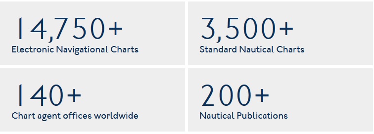
As leaders in our field, our global reputation is based on the reliability of hydrographic and geospatial information. That's why we employ global experts including cartographers, hydrographic surveyors, tidal experts and master mariners to ensure this information is up to date.
These experts help us to collect, compile, analyse and supply global maritime data in a wide variety of formats, including millions of items per year under the ADMIRALTY Maritime Products & Services brand. This data includes tidal height and tidal stream data, navigational hazards, over 70,000 individual light structures, port information, climatic conditions, maritime radio communications information and security-related information.